INGRES-3
CODE: CTM2010_21229
Flujo Mediterráneo en Gibraltar, influencia en la ventilación de las aguas Mediterráneas y primera evolución y acoplamiento con las aguas centrales en el Golfo de Cádiz
| CHIEF RESEARCHER | Jesús García Lafuente glafuente@ctima.uma.es |
| FUNDING | 133.000 € |
| FUNDER | Ministerio de Economía y Competitividad |
| DURATION | 2011 - 2013 |
| Members | |
OBJECTIVES
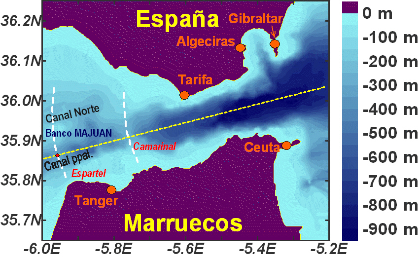
INGRES 3 (CTM2010-21229-C02) is a coordinated project funded by the old Spanish Ministery of Science and Innovation (presently by the Ministry of Economy, MINECO) and is the natural prolongation of the former R EN2003-01608 (INGRES1) and CTM2006-02326 (INGRES2) projects. It is a cooperative research between the University of Malaga and the Spanish Institute of Oceanography and will end during year 2014. The main objective of INGRES3 (and of the previous INGRES1 and 2) was the long-trem observation of the Mediterranean outflow through the Strait of Gibraltar and in its way to the open ocean. Water properties of the densest, deepest water leaving the Mediterranean Sea are monitored by the observation station as well. The station is equiped with an uplooking ADCP and conductivity/salinity sensors in a mooring line of hardly 20m tall (sketch on the right). The monitoring station is included in the HydroChanges network of the observation of the Mediterranean Sea, which is sponsored by the CIESM. The site selected for monitoring is Espartel sill, at the westernmost section of the Strait. Although it is not the main sill of the Strait of Gibraltar, which is Camarinal sill, Espartel provides very suitable conditions for a satisfactory monitoring, among which we underline the permanence of the hydraulic control of the outflow that makes the flow estimation be more reliable. Despite the intense and prevauiling tidal currents oin the area, the deep flow at this sill rarely reverses, keeping on a westwards direction which is modulated by tides. Tidal reversals are the rule at Camarinal sill, which poses extra-difficulties when estimating flows based in a single ADCP mooring line.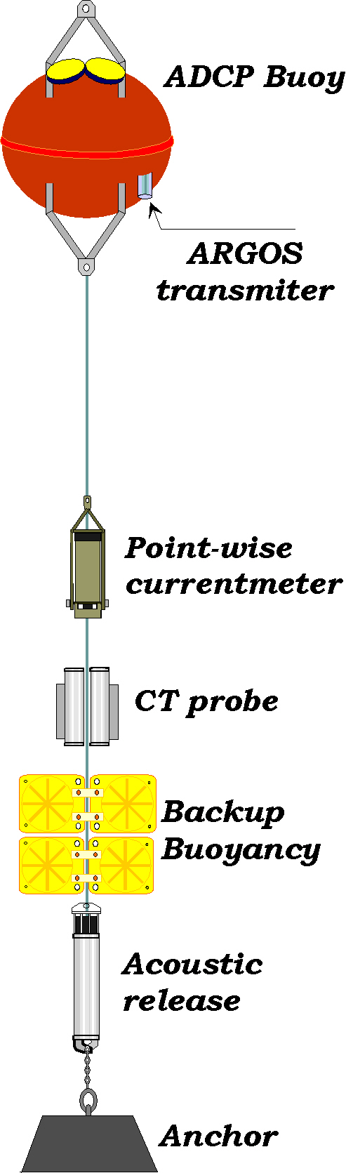 Another objectives of the project is the analysis of the cross-strait spatial structure of the outflow, the investigation of mixing in the Tangier basin and the role played by tides and other subinertial forcings in the aspiration of Western Mediterranean Deep Water from the Alboran Sea in the Mediterranean to get insight in the ventilation of the Mediterranean basin. To this aim and additionally to the information provided by the monitoring sta tion, INGRES 3 addresses high resolution numerical simulation usiing MITgcm circulation mod e l in collaboration with the Climati c Modellin Unit of ENEA (Rome, Italy, Dr. G. Sannino)
RESULTS
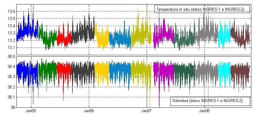
Time series of temperature and salinity at 15m above sea floor during part of the monitoring period are showed below. A remarkable feature is the temperature drop observed by the end of 2005 and 2006 winters, which has been associated with the noticeable formation of Western Mediterranean Deep Water (WMDW) that took place those years (Garcia Lafuente et al., 2007. A diagram showing the fraction of each water mass contributing to the outflow (blue=AW, orange=LIW, brown=WMDW) is presented below. It shows how the temperature drops are accompained by sudden increases of the WMDW fraction.
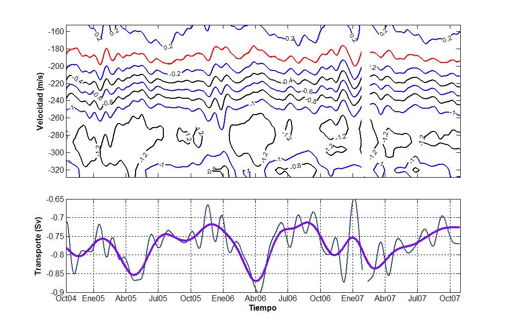
 Subinertial velocity shows peaks above 1.2 m/s around 280-300m depth while the null velocity interface is located at 200m. The figure indicates that seasonal maximum is achieved around March-April that in turn suggests a relationship between outflow maximum and the formation of deep waterd in the Mediterranean Sea.
 Within the objectives of the project was the correlation of the flows observed over the sills of Espartel and Camarinal. A secondary mooring line was deployed at Camarinal and the joint analysis of those observations and the output of a numerical model allowed for a very suitable depiction of tidal behavior inthe Strait of Gibraltar (Sánchez Román et al., 2008, 2009).
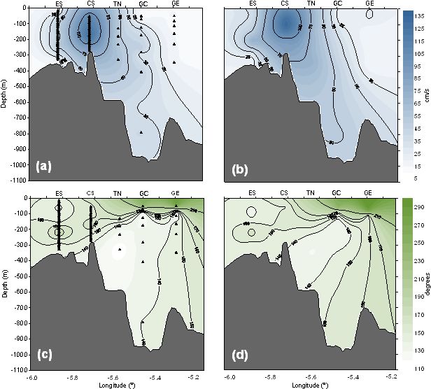
Tidal maps of M2 (left) and S2 (right) along the main axis of the Strait of Gibraltar. Labels on top stand for Espartel Sill (ES) Camarinal Sill (CS), Tarifa Narrows (TN), Gibraltar-Ceuta section (GS) at the eastern part of the Strait. Upper panels are semimajor axis, lower panels are phases
A relevant result of the project was to check that the hydraulic control at Espartel sill was a nearly permanent feature, a fundamental hypothesis of the monitoring strategy that is behind the initial decision of deploying the monitoring station at this special site. Here, hydraulic control is understood as the fact that the outflow velocity is always greater than the first baroclinic wave speed in some portion of the water column, usually the deepest portion of the column (see figure). The vertical distance between the sea floor and the intercept of the observed and the bariclinic mode velocities would give the thickness of controlled flow. This thickness (blue shadow) is always less than the Mediterranean layer (fucsia) showing that not all the outflow undergoes hydraulic control . This interesting result is of very practical importance as it warranties that the water mass sampled by the CTD is always moving out of the Mediterranean sea and that not recirculations will be observed.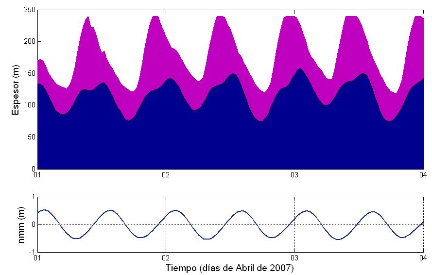 MITgcm is the numerical model adapted to the Strait of Gibraltar geometry. The model has been run in collaboration with the Modeling Climatic Unit of ENEA (CNRS-Italy, Dr. G. Sannino). Also, and within the Atlantic side of the Strait (Gulf of Cadiz) ROM is run in collaboration with the University of Lisbon (Dr. A. Peliz) and researchers of the Spanish Oceanographic Institute (Drs. R. Sanchez Leal, M. Ruiz-Villareal). The non-hydrostatic version of MITgcm has great potential to simulate non-linear phenomena, particularly the lartge-amplitude intenal wave trains formed periodically in the main sill of Camarinal by tidal interaction. The model captures quite well the formation and evolution of these wave trains (Vlasenko et al., 2009; Sánchez Garrido et al, 2010)
 More scientific results of INGRES projects can be seen in these papers: