ESMER4
CODE: PCM-00005
EStación de Monitorización del Flujo de agua Mediterránea saliente por el Estrecho de GibraltaR: 4º periodo
| CHIEF RESEARCHER | Jesús García Lafuente glafuente@ctima.uma.es José Carlos Sánchez Garrido jcsanchez@ctima.uma.es |
| FUNDING | 249.863,95 € |
| FUNDER | Plan Complementario de Ciencias Marinas y de Recuperación, Transformación y Resiliencia |
| DURATION | 2022-2025 |
| Members | |
OBJECTIVES
BACKGROUND: Importance of Monitoring Mediterranean Water in the Strait of Gibraltar
The Strait maintains a bidirectional water flow driven by evaporation and the loss of buoyancy of waters in the Mediterranean Sea. The Atlantic surface waters that enter the Mediterranean increase in density and sink, returning to the Atlantic at depth as Mediterranean waters. The outgoing flow is constrained by the bathymetry of the Strait (Figure 1), which, along with the Mediterranean climate, determines the characteristics of the intermediate and deep waters of this sea (Bryden & Kinder, 1991). Changes in the latter will produce changes in these, which will manifest here sooner than in other parts of the world due to the relatively small volume of this inland sea. For decades, there has been evidence of long-term changes in the hydrological characteristics of Mediterranean waters, confirmed by more recent observations (García Lafuente et al., 2021), which are reflected in the outflow (Sammartino et al., 2015), with the natural observation point being the Strait of Gibraltar, making it the ideal place to track the consequences of climate change in the Mediterranean. Furthermore, the role of Mediterranean waters in the general ocean circulation within the context of global climate remains under study: the outgoing flow is a source of momentum and salinity to include in general circulation models that affects the Atlantic Meridional Overturning Circulation (AMOC). No less important is the flow of organic carbon entering the North Atlantic, transported by the outgoing flow through the Strait (Flecha et al., 2019), which contributes to the acidification of this ocean and, more specifically, to the lower return branch of the AMOC that exports carbon to the Southern Ocean. Changes in the properties of the water flow through the Strait of Gibraltar would have consequences for that global circulation and the processes associated with the global ocean carbon cycle, as shown by recent numerical models. Such models require detailed knowledge of these biogeochemical flows to the North Atlantic from the Strait for global balances of these properties.
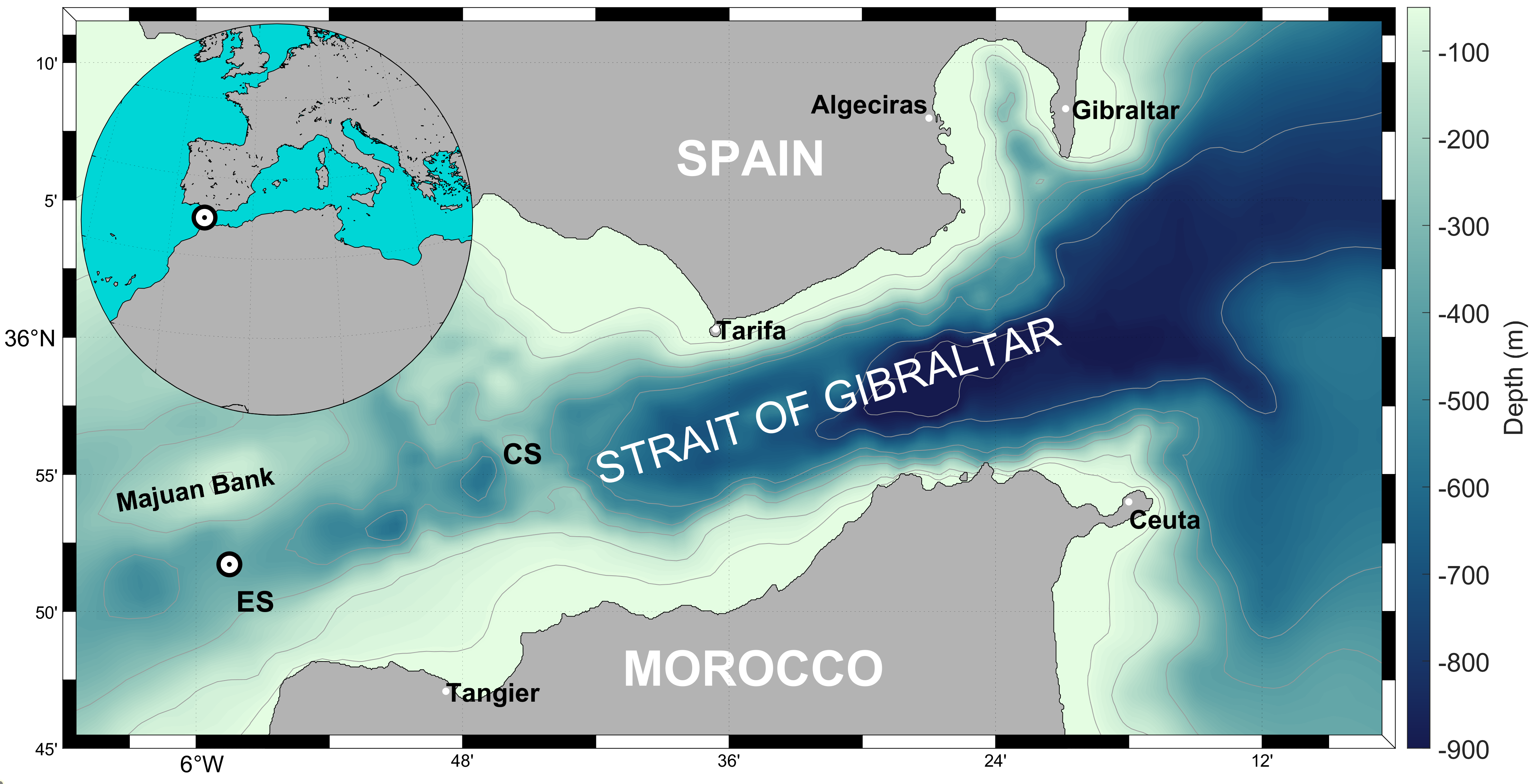
Figure 1. Map of the Strait of Gibraltar with the position (white circle) of the monitoring station in Espartel Sill (ES) (Sammartino et al. 2024)
With this motivation, GOFIMA initiated a monitoring program with the objective of monitoring the dynamics and the thermohaline properties of the Mediterranean water flowing out to the Atlantic Ocean. This was done through the series of Projects INGRES (1st period of the monitoring station: 2004-2013). The latest of them, INGRES-3, led by GOFIMA and the Oceanographic Center of Cadiz of the Spanish Institute of Oceanography, aimed to define a maintenance strategy for the monitoring station to keep it operational after the project ended. The responsible parties for both subprojects agreed to include such maintenance as one of the tasks in the STOCA project ("Time Series of Oceanographic Data in the Gulf of Cádiz"), which the IEO-CSIC had implemented in the Gulf of Cádiz since 2010, as part of the monitoring programs developed by this institution in coastal areas of Spanish territory. The designed instrumentation line was short (Figure 2). It consisted of a subsurface buoy housing a long-range ADCP current profiler (RDI 75 kHz), ARGOS beacons that emitted in case the line encountered an accident and unexpectedly surfaced, CTD sensors beneath the buoy to measure the hydrological properties of the outgoing flow at that depth, along with a pointwise current meter to complete the vertical profile provided by the ADCP, as the latter does not measure below its location. The final element was an acoustic release that anchored the line to a ∼1-ton concrete block.
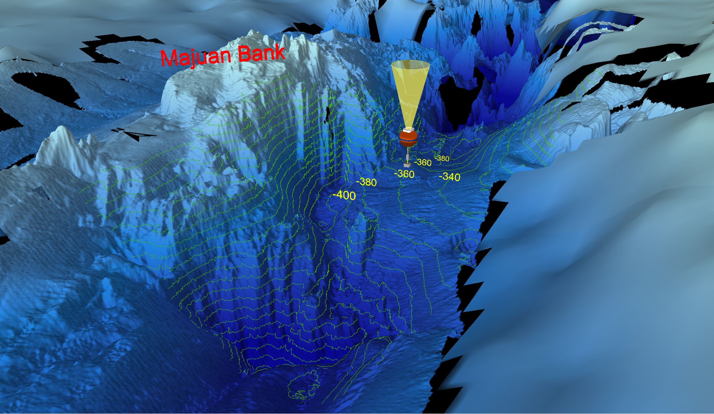
Figure 2. 3D map of the Strait of Gibraltar seafloor (southern channel of the Espartel Sill) showing the location of the monitoring station.
Aware of the interest in monitoring other biogeochemical variables, the collaboration framework was expanded to include researchers from the Institute of Marine Sciences of Andalusia (ICMAN-CSIC) working in the field of marine biogeochemistry, characterizing the contribution of the ocean to the exchange of greenhouse gases with the atmosphere and its consequences on marine ecosystems. For this research group, continuous series of biogeochemical variables were of great value, so it was agreed to expand the instrumentation of the line with new pH and CO2 sensors and contribute to the station's maintenance. The structure of the line was reformed to incorporate these new instruments (2nd period of the monitoring station: 2013-2018). The next period (3rd period of the monitoring station: 2018-present) began with the renewal of much of the line’s equipment, including a new dissolved oxygen (O2) sensor and a second, lower-range ADCP (500 kHz), which was placed on the buoy looking downwards to resolve the portion of the water column not measured by the main ADCP, which looks upwards.
OBJECTIVES: 4th Period of the Monitoring Station
The basic objective of the project is to support and complete the oceanic monitoring station for Mediterranean flow located at the Espartel Sill (see location in Figure 1), so that it can continue to provide quality data and carry out its relevant scientific mission in the short-to-medium term. This requires periodic renewal of the scientific equipment installed at the station with instruments that incorporate technological advances and the addition of new sensors to track the evolution of other variables of interest. The notable prior experience of the research team allows for estimating that the period for renewal of the equipment will be about five years, which provides an increase in the durability and performance of the monitoring station. During this time, efforts will continue to manage grants and support to ensure continuous monitoring, relying on the various R&D&I calls that are published, as is being done at present. The motivation to proceed in this way is the strong belief that the scientific value of the data collected by this observation platform grows exponentially with the length and quality of the time series it generates, particularly in the current context of climate change. Cutting off these time series would be a regrettable mistake.
From a practical standpoint, the basic goal is the acquisition of the requested scientific equipment that will allow for duplicating, improving, renewing, and completing the deployed instrumentation. Unfortunately, the continuity of the series has been interrupted on few occasions, when the line suffered breaks or loss due to fishing activities or mechanical failure of the structure, which corresponds to 14.5% of the series length (see Figure 2a of Sammartino et al. 2024). In these situations, having new instrumentation allows for replacing damaged material and minimizing data gaps in the historical time series being collected. Linked to this central objective of extending the observation platform over time, there are two more technical-scientific objectives:
- The first is the information processing to create time series of directly-sampled (temperature, conductivity, dissolved oxygen, pH, CO2) or indirectly inferred (salinity, density, flows, height of the interface between Atlantic and Mediterranean waters) variables with the best quality standards. The collected data will undergo rigorous quality controls and be associated with estimated quality tags. The generated series will be incorporated into open-access data repositories after a period reserved for the research team to exploit the data.
- The second is to continue refining and increasing the spatial resolution of the numerical model implemented by GOFIMA in the Strait area, whose first version dates back to 2010 (Sánchez-Garrido et al., 2011). The information provided by the model is a very valuable tool when estimating flows from the current profiles collected by the ADCPs of the station, as spatial patterns of the transversal structure of the flow can be extracted from the modeled data, which cannot be inferred from observations taken at a single point. In recent years, the model has evolved in complexity and increased spatial resolution, in parallel with the increasing computational power of the computer running it (PICASSO supercomputer at the University of Málaga). The evolution will continue throughout the project to provide more detailed structures, which will improve the quality and accuracy of the estimated Mediterranean outflow series.
RESULTS
The project aims to consolidate and ensure the continuity of an observing platform that has been operational since 2004, but which still requires the necessary scientific infrastructure to face the near future with sufficient certainty. The station is currently in its third period of operation and some of the instruments used are showing signs of wear and tear, which can be remedied by renewing and updating the equipment in order to start a new period of observation, which would be the station's fourth period.
PLOSEG: Plataforma de Observación Submarina del Estrecho de Gibraltar
The Platform for Underwater Observation of the Strait of Gibraltar (PLOSEG) represents a substantial change in the architecture of the monitoring station. It evolves from a traditional mooring line to a “LANDER” type structure specially designed to be deposited on the seafloor. Two main advantages characterize PLOSEG. On the one hand, the distance from the main ADCP to the bottom is significantly shortened, reducing it from about 17 m to barely 0.5 m. This ensures almost total coverage of the water column with less blaking zones. A second ADCP, attached to the same structure, allows profiling of the bottom layer. On the other hand, the fixed structure completely eliminates vibration, tilt or subsidence of the traditional subsurface line, providing a clear advantage in terms of quality of the profile obtained and reduction of background noise. It is planned to complement PLOSEG with a second line where the biochemical sensors would be installed and the conductivity/temperature sensor would be duplicated (Figure 3b), in order to maintain the continuity of the historical series.
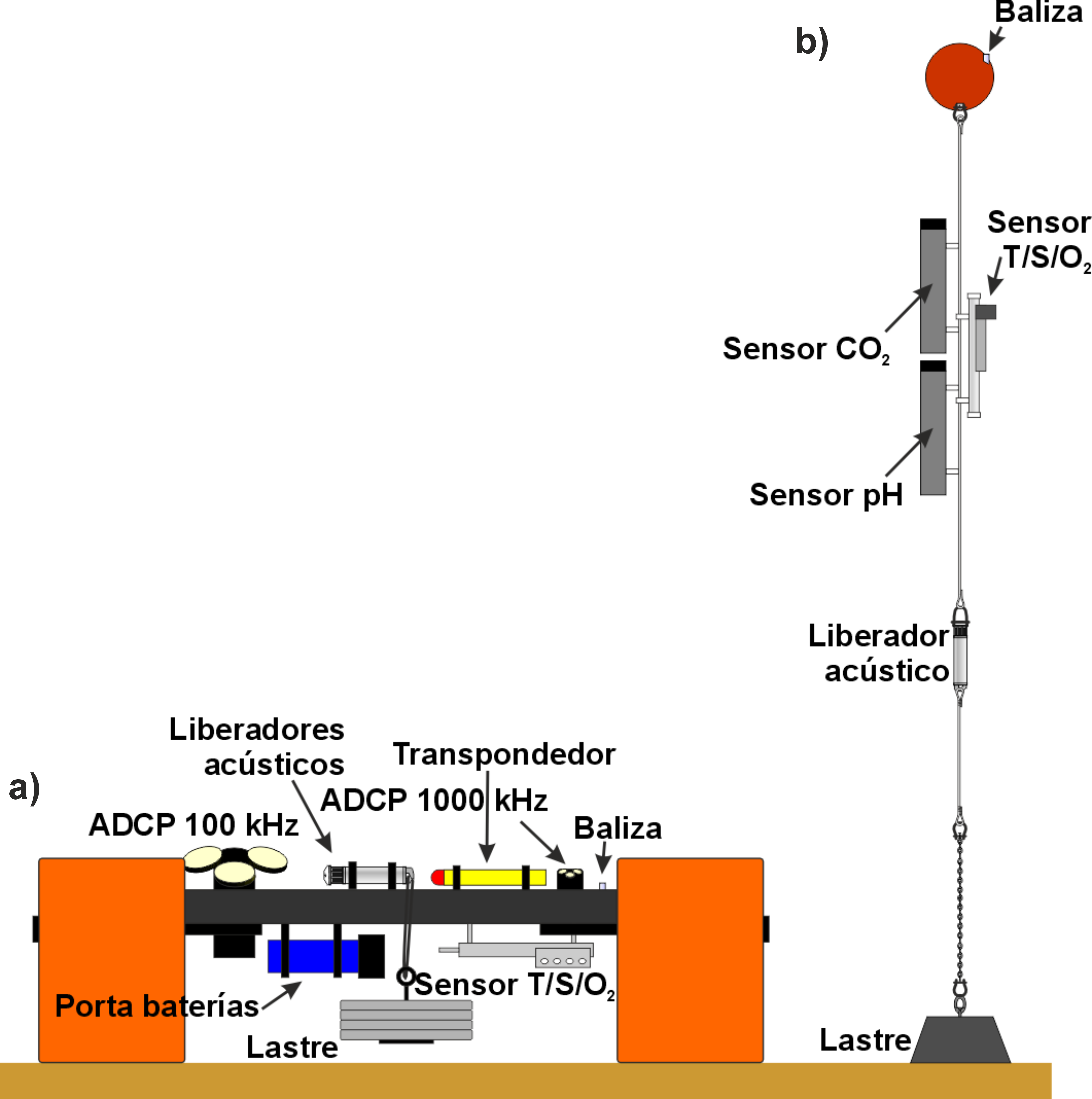
Figure 3. Deployment scheme of the new monitoring platform in the Strait of Gibraltar (a), alongside the currently used sub-surface structure (b).
The PLOSEG is a novel system, designed by the GOFIMA researchers. It is a compact, multi-instrument module equipped with its own flotation and release system. Its main body is a pseudo-triangular plate, 1.15 meters wide and 70 mm thick, supported by three thick legs (Figure 4). On top of the plate, two ADCPs are installed: a Nortek Signature 100 short-body model with external power, and a Nortek Signature 1000. Two paired iXblue Oceano R5, coustic releases are clamped on one corner, attached to a ∼90 kg fungible weight made by a series of used car-brake discs, which keep the platform anchored to the seabed through a central aperture in the plate. A Kongsberg cNODE Midi, which transmit the position and inclination of the platform, is installed on one edge. Two Nortek battery holders, housing two 18 V – 540 Wh alkaline batteries each, are clamped on the lower surface of the plate, along with a SeaBird SBE37-SMP-ODO sensor for measuring conductivity, temperature, and dissolved oxygen. conductivity/temperature/dissolved oxygen sensor. The buoyancy of the system is provided by three DeepWater Buoyancy floating modules which have been crafted following a custom design provided by GOFIMA (Figure 4). The platform also features two Argos Xeos XMA-11K positioning beacons for location in the event of accidental release. The material employed for the construction of the plate and associated clamps is DELRIN, a homopolymer acetal with exceptional stiffness and very precise machining, while the hardware components are fabricated from titanium, aimed at reducing oxidation and the costs of the periodic maintenance. The platform is designed to be deployed by means of an auxiliary release LANDERPICK, lowering the entire structure to the seabed.
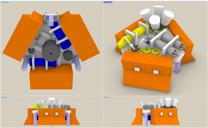
Figure 4. Three-dimensional sketch of the new monitoring station "PLOSEG".
During the first half of 2025, work was carried out on the assembly and development of the PLOSEG platform (Figure 5 and Figure 6).

Figure 5. Image collage of the construction and assembly of the new "PLOSEG" monitoring platform.
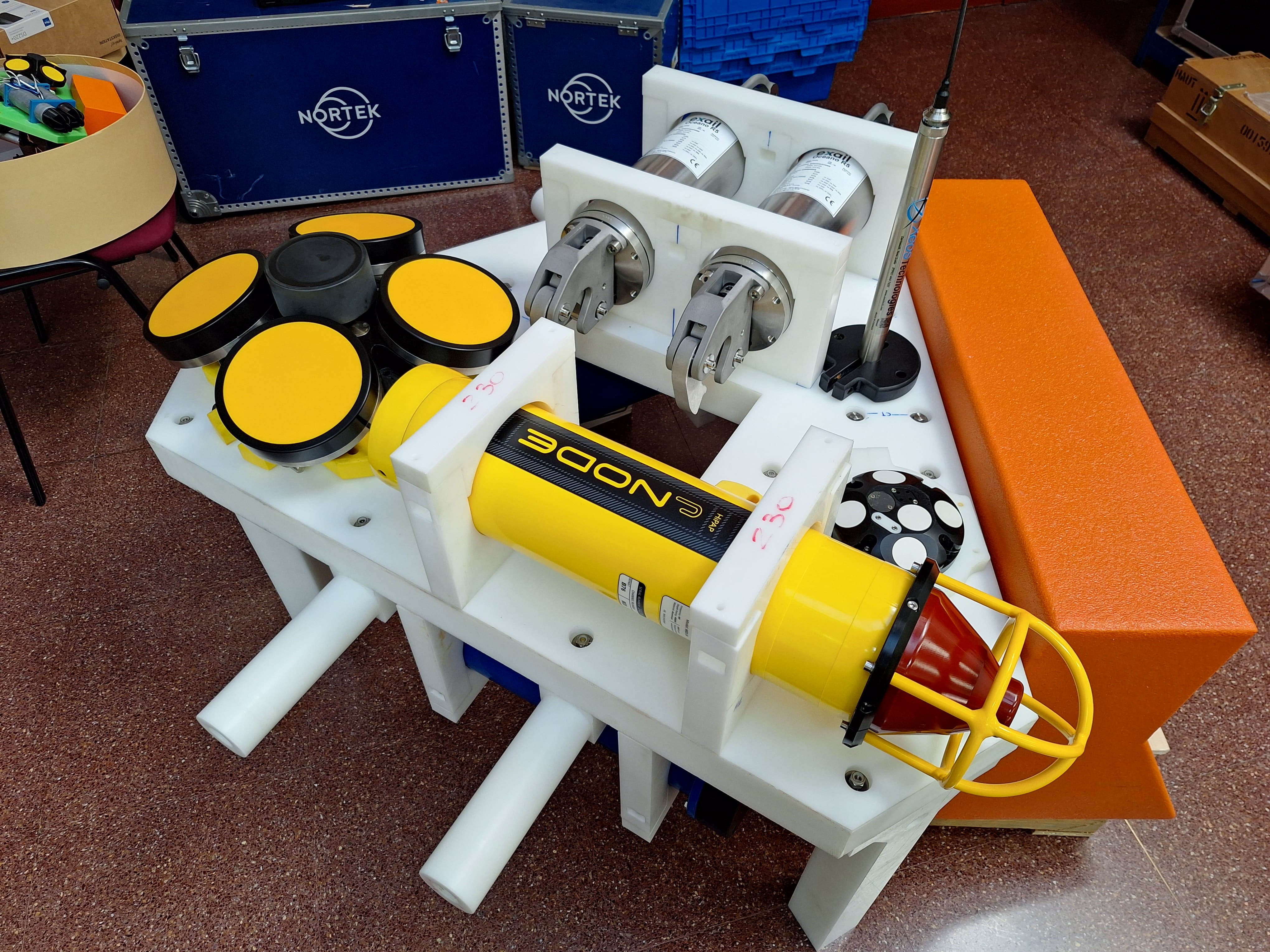
Figure 6. Final assembly stage of the new monitoring platform. The two current profilers, the underwater localization system, the satellite tracking beacon, and the two acoustic releases are visible. On the right, one of the three floats is already installed in position.
In June 2025, shallow-water tests were successfully conducted to evaluate the anchoring and deployment of the platform using the LANDERPICK system. These trials allowed for adjustments to the original design to improve maneuverability and functionality prior to the definitive deployment. One of the key modifications involved changing the location of the beacons, as tests revealed that the platform turns upside-down during the surfacing process once the ∼160 kg anchor weight is released. The two beacons, which had previously been placed on the plate in an upward- and downward-facing configuration, were relocated to the underside of two of the three floating modules. A series of labels and writings has been applied to all instruments and floating modules with contact information to be used in case of accidental surfacing, and the entire platform was painted in high-visibility yellow to facilitate its recovery upon release. Following these and other minor modifications, the platform saw its inaugural deployment in the Strait of Gibraltar in December 2025.
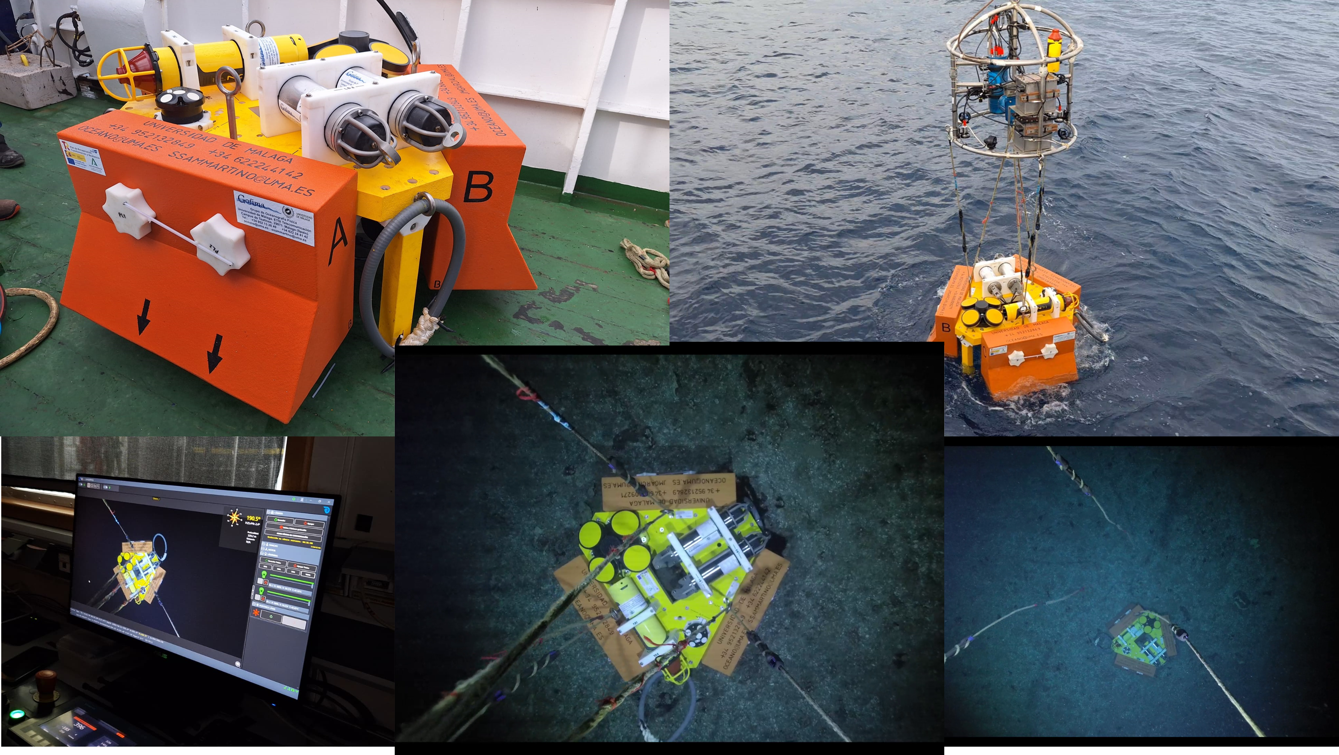
Figure 7. Sequence of procedures for the PLOSEG deployment using the LANDERPICK auxiliary launch system, from deck operations to its final placement on the Espartel Sill seabed.
Although the external battery holders allow the main current profiler housed in PLOSEG to operate autonomously for up to one year, the initial campaigns are intended to evaluate the performance of the fixed platform against the subsurface mooring line by comparing the measurements provided by the two infrastructures directly. Accordingly, the instruments housed in the platform were configured to have the same deployment duration as the mooring line instruments, but with substantially higher temporal resolution, prioritizing higher-accuracy observations over longer autonomy. The next recovery campaign, which will verify the effectiveness of PLOSEG, is scheduled for June 2026!
PLOSEG deployment maneuver at the Espartel Sill. December 2025.
At the scientific level, in addition to presenting the monitoring results at national and international conferences (e.g. EGU, IUGG, AGU...), it is planned to continue publishing results based on the data collected by the station in high-impact journals, as has been done so far. In particular, new observations will be used to confirm or refine previous conclusions regarding significant changes in the composition of the outflow, as presented in the recent study "Hotter and weaker Mediterranean outflow as a response to basin-wide alterations" (García Lafuente et al., 2021), for which extended time series are essential.
3D interactive model of the new monitoring platform (PLOSEG)FILES
- ThinkinAzul Andalucía
- Resumen de la comunicación presentada al congreso MARTECH 2025 (28-29 mayo, Pasaia, Gipuzkoa).
- Póster presentado al congreso MARTECH 2025 (28-29 mayo 2025, Pasaia, Gipuzkoa).
- Resumen de la comunicación presentada al congreso de Jóvenes Investigadores del Mar (JIs del Mar) 2025 (5-7 noviembre 2025, Huelva).
- Póster presentado al congreso de Jóvenes Investigadores del Mar (JIs del Mar) 2025 (5-7 noviembre 2025, Huelva).