MOCBASE
CODE: P12-RNM1540
Modelización y caracterización del sistema circulatorio de la Bahía de Algeciras para el establecimiento de directrices de actuación ante situaciones de emergencia
| CHIEF RESEARCHER | Jesús García Lafuente glafuente@ctima.uma.es |
| FUNDING | 118.757 € |
| FUNDER | Junta de Andalucía |
| DURATION | 2014 - 2017 |
| Members | |
OBJECTIVES
The project, within the framework of the call "Proyectos de Excelencia del Plan Andaluz de Investigación", focuses on the detailed study of the Algeciras Bay with the aim of providing the local autorities with reliable information applicable to the management of the natural environment. The project presents the following objectives:- Describe the circulation of the Algeciras Bay, based on historical observations completed with new ones that fill the gaps of the available information.
- Employ the numerical model developed by the Group within the operational oceanography project SAMPA (http://sampa-apba.puertos.es/) in hindcast mode, to investigate the flushing times of the sub-surface and deep waters of the Bay.
- Develop high resolution models of the port areas and its neighboors, nested to the previous model, to investigate the inner dynamics of the Port and assess reliable proxies of water quality.
- Generate different scenarios of the circulation regime of the Bay, with the aim of studying the dispersion-diffusion of pollutants.
RESULTS
OBJECTIVE 1: General circulation of the Bay of Algeciras
The general circulation of the Bay of Algeciras is is dominated by tide, modulated by the subinertial dynamics that in both cases is forced through its open boundary with the Strait of Gibraltar. The water column is stratified, with Atlantic waters (fresher and warmer and hence less dense) over Mediterranean waters (saltier and cooler and hence denser). An interface layer is located between them, at an averaged depth of 70 m. The dominant constituent is the semidiurnal lunar (M2) whose behavior in the longitudinal section of the Bay is displayed in the figure, adapted by the work published in Continental Shelf Research.
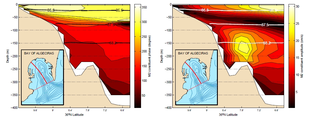
Phase (degrees, left) and amplitude (cm/s, right) of the tidal current in the Bay of Algeciras along the red line indicated in the inset.
The Atlantic layer is in quadrature with the barotropic tide (sea level), determining the tidal dynamics schematized as follows:
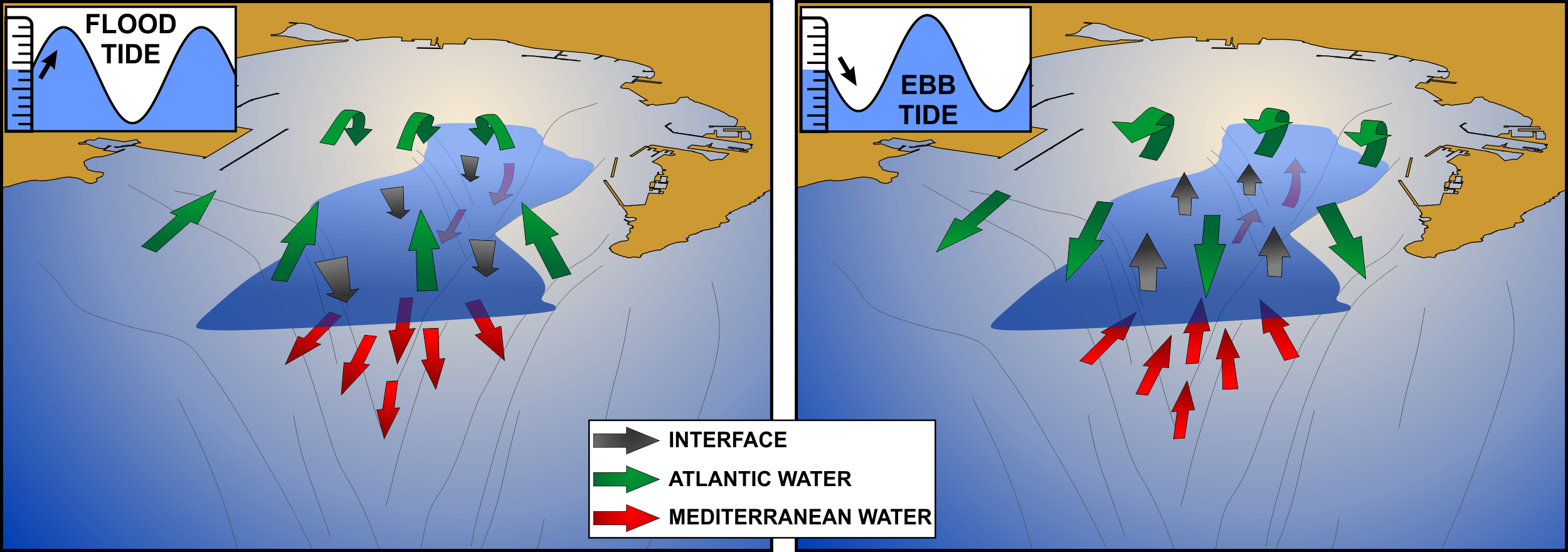
Functional scheme of the tidal dynamics of the Bay of Algeciras.
- In flood tide the Bay is flooded with Atlantic water entering at surface, deepening the interface and forcing the Mediterranean water to leave the Bay at the seafloor toward the Strait.
- In ebb tide is the Mediterranean water that enters the Bay at the seafloor, raising the interface and pushing the Atlantic surface water out toward the Strait.
At subinertial timescale (longer than tidal periods), winds modulate the circulation of the surface layers, piling water inside the Bay under Easterlies and ventiling the inlet more efficiently under Westerlies, as shown by the following figure extracted by the work published in Marine Pollution Bulletin.
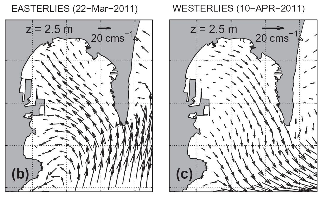
Surface circulation under Easterlies (left) and Westerlies (right).
OBJECTIVE 2: flushing times of sub-surface and deep waters
The water renewal efficiency of the Bay relies on different factors, both on tides and winds as external forcings, as well as on the diversity of the water masses that occupy the Bay as intrinsic characteristics. With the aim of analyzing the renewal patterns of the Bay a series of virtual tracers release experiments have been carried out. They have been released at regular intervals in both layers of the Bay, and their evolution tracked. The following figure, extracted by the work published in Marine Pollution Bulletin, shows the time series of the flushing times (e-folding times) computed on the decay curves of the tracers concentration, along with the zonal wind stress (indicating the meteorological forcing) and the sea level (indicating the tidal forcing).
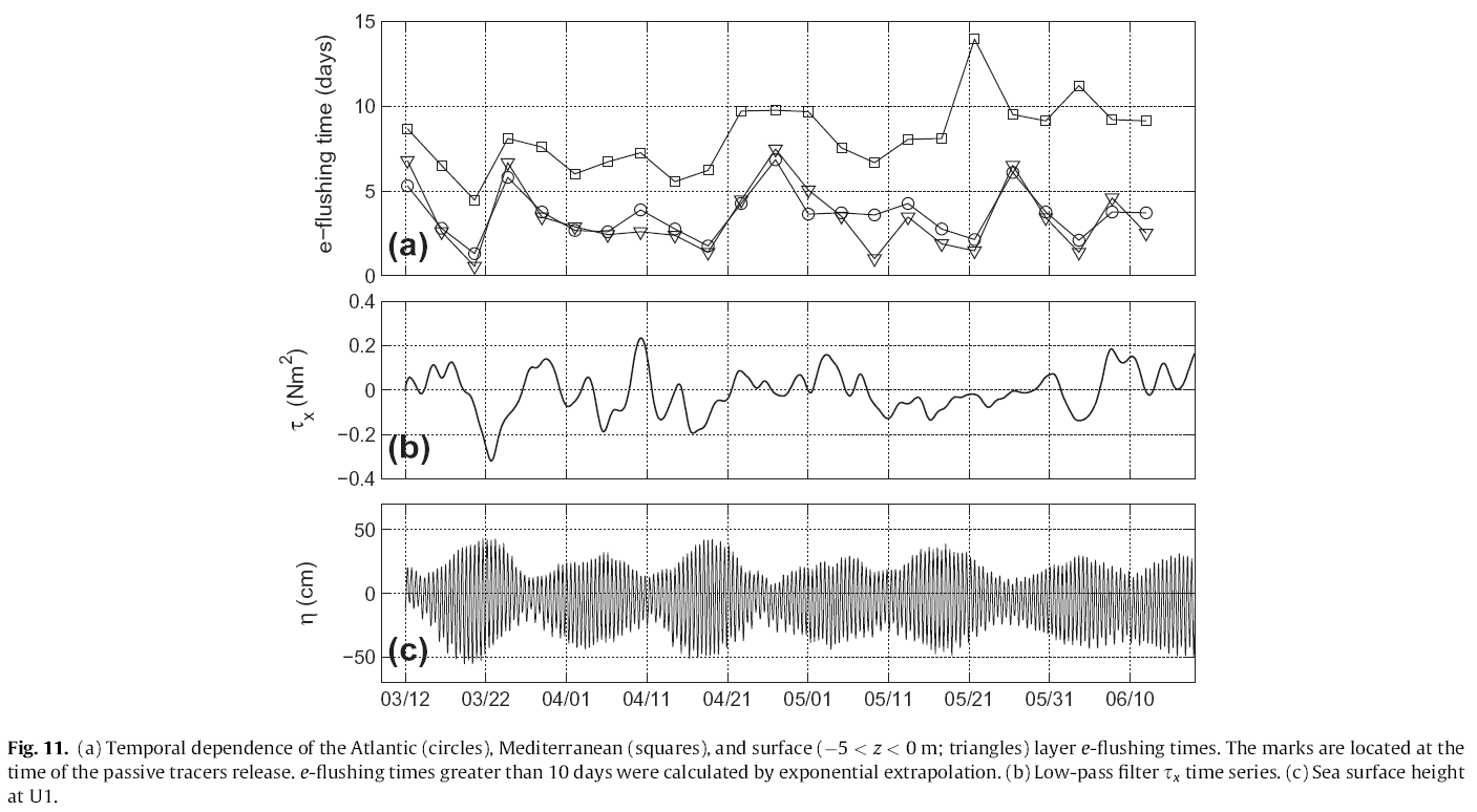
Flushing times computed on passive tracers.
The Atlantic layer ventilates faster than the Mediterranean, a process clearly related with the aspiration that the strong Atlantic Jet flowing through the Strait toward the Mediterranean Sea, exerts on the surface layer. The fraction of particles released in the Atlantic layer, once out of the Bay, has few chances of coming back inside because they are advected by the Jet. This does not occur with the particles released in the Mediterranean layers that do have more possibility of returning inside the Bay being not affected by the Jet.
The correlation between the flushing times of the Atlantic layer and the fortnightly modulation of the sea level (spring-neap tide cycle) is noticeable. On the contrary, the Mediterranean layer seems to respond to a more meteorologic modulation, showing shorter flushing times when the atmospheric variability is greater and vice-versa. A different approach, applicable to the analysis of the flushing patterns of the Bay, is based on the computation of Lagrangian trajectories of virtual particles. A total amount of 4000 particles have been released in the Atlantic layer and their trajectories have been tracked for three days.
In the animation the color scale indicates the depth of the initial position of the particle, while the temporal evolution of the sea level is shown in the inset.
The Lagrangian approach described so far has been applied in a more sophisticated way to the high resolution models developed later and described in the next section.
OBJECTIVE 3: High resolution models of the Bay of Algeciras
The spatial resolution of the current SAMPA model is not able to resolve the port dynamics of the Bay of Algeciras. Hence, to cope with this gap, a new nested model has been implemented, able to provide a a progressively increasing resolution through the coupling of three different domains. The first domain (REG, panel a) corresponds to the extent of the previous SAMPA model, it presents a total of 46 vertical levels of varying thickness (finer at surface where it presents a thickness of 5 m), and a total amount of around 1.6 millons nodes. To the REG domain the BAM (from Bay of Algeciras Medium resolution) domain is nested, covering the whole Bay and half the Strait approximately (panel b). The domain sports a downscaling ratio of 1:4 with the REG domain, reaching a resolution of 150 m inside the Bay, a greater vertical resolution, with its 35 levels distributed over a rather shorter maximum depth and a surface cell of 3 m thickness, and a total amount of slightly less than 300.000 nodes. This intermediate domain feeds the very high resolution domain BAH (from Bay of Algeciras High resolution), which attains a 30 m resolution in the inner part of the Bay (panel c). Its downscaling ratio with BAM domain is 1:5 and its vertical resolution improves further providing a surface cell thickness of 2 m over 35 total levels.
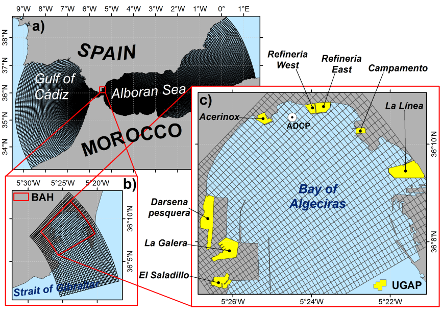
Domains of the nested model: REG (panel a), BAM (panel b) and BAH (panel c). In the panel b) the extent of the BAH domain is also shown in red. The grid of the BAH domain in panel c) has been represented with one of 5 cell, for the sake of clearness. The docks (UGAPs, see text) analyzed in the water quality module are shown in panel c) in yellow.
For the REG domain the following forcings are considered:- Copernicus Marine IBI (Iberian Biscay Irish) Ocean Analysis and Forecasting system, CMEMS-IBI hereinafter, (Sotillo et al. 2015), provinding the baroclinic fields of temperature, salinity and horizontal velocity prescribed at the open lateral boundaries
- The storm surge operational NIVMAR model (Fanjul et al. 2001) gives a barotropic correction for the normal velocity at the lateral boundaries in order to include the effect of the atmospheric pressure over the Mediterranean basin on the water exchange through the Strait of Gibraltar.
- The Spanish Meteorological Agency forecast service based on the HIRLAM model applications (Cats and Wolters 1996; Navascués et al. 2013) provides the atmospheric forcing (wind stress, shortwave and longwave surface radiation, precipitation, air humidity and temperature)
- The tidal barotropic velocity computed from the harmonic constants derived by LEGOS-POC/CLS models (Carrère and Lyard 2003)
In BAM and BAH domains the atmospheric forcing provided by HIRLAM is interpolated at the surface resolution of the grid, while the baroclinic fields of the initial and boundary conditions are provided by the corresponding nesting models.
Altough the SAMPA model, coinciding with the current REG domain, has been widely validated in the past (Sammartino et al. 2014; Sánchez Garrido et al. 2014; Sotillo et al. 2016; Soto-Navarro et al. 2016; Jordà et al. 2017), the domain nested to the new model needs a finer validation which could assess the reliability of the solutions at Port and Bay scale. It requires new observations. In October and December 2015, within the framework of the MOCBASE project and counting on the collaboration and logistic support of the Bay of Algeciras Port Authority, a series of oceanographic cruises have been carried out. In the one hand two deep moorings were deployed, one from October 2015 to December 2015 and the other from December 2015 to March 2016, located around the Algeciras canyon at 250 m depth approximately, equipped with current profilers and temperature/salinity probes. In the other hand two shallow moorings were deployed at around 30 m depth in the northwestern margin of the Bay, equipped with a high frequency current profiler.
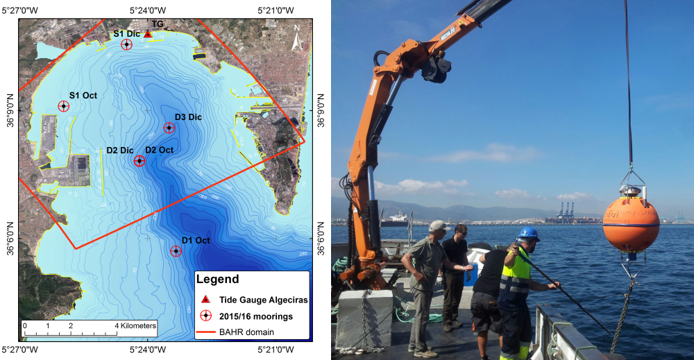
Map of moorings location (left) and deployment of one of them (right).
The model validation has a two-fold aim of assessing the reliability of the solutions and estimating the improvement provided by the increase of resolution in the Port areas of the Bay. As an example of it, the following figure shows the harmonic constants of the M2 constituent in the shallow mooring S1, comparing observations and simulated data in the REG and BAH domain.
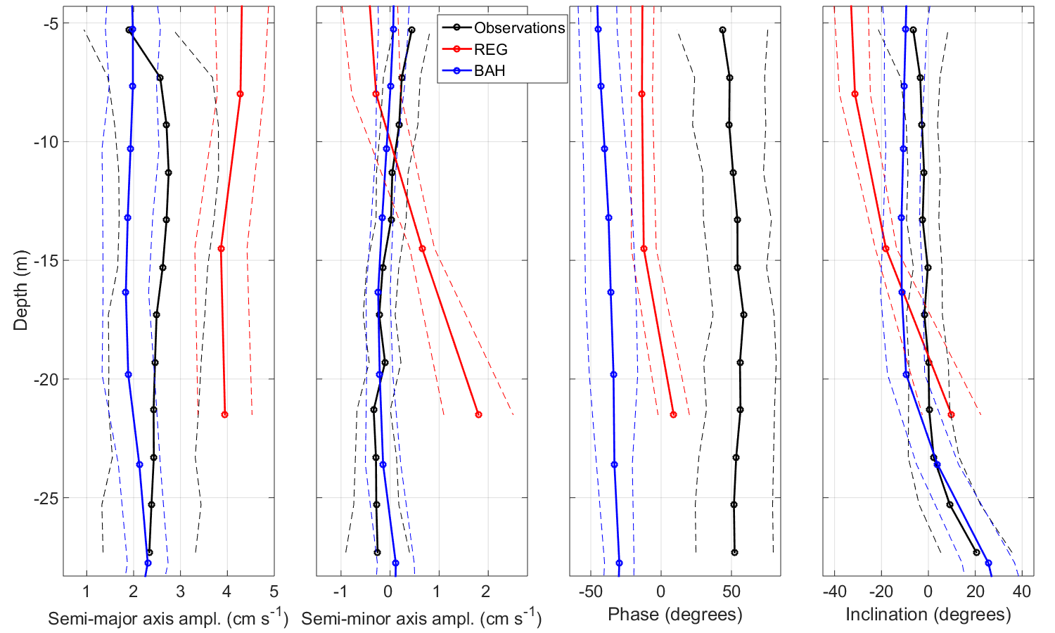
Harmonic constants of the M2 constituent observed and simulated in S1 mooring.
These results, and the others detailed in the project reports, demonstrate the noticeable improvement of the model solutions provided by the nested models designed to increase the spatial resolution. This is one of the main achievements of the project.
OBJECTIVE 4: Dispersion-diffusion of pollutants
Coupled to the numerical model developed in the project, a module for the assessment of the flushing times of the waters of the Bay has been developed, addressed to evaluate the environmental quality of the docks of the Port. The module exploits the Lagrangian trajectories of virtual particles to estimate some water renewal indexes. The particles tracking algorithm is a version of the Runge-Kutta 4th order scheme, specifically adapted to be integrated in a nested model with curvilinear grids and particularly sensitive to the interation of the particle with the inner rigid boundaries of the docks.
In order to obtain the most representative characterization of the external conditions that could affect the renewal efficiency of the docks, a 61 days hindcast has been executed, in which the following variety of conditions has been found:
- Winds: Westerlies, Easterlies and calm
- Tidal strength: spring, neap
- Tidal phase: flood, ebb
From the combination of these external conditions a total of 10 different scenarios have been defined (calm conditions have been met only in neap tide), which have been applied as initial conditions of a series of experiments of virtual particles release in 8 different docks identified as UGAPs, from the Spanish acronym of Port Water Management Unit. The following figure shows the wind and sea level conditions met during the two months simulation, and indicates the time of release of the experiments in magenta.
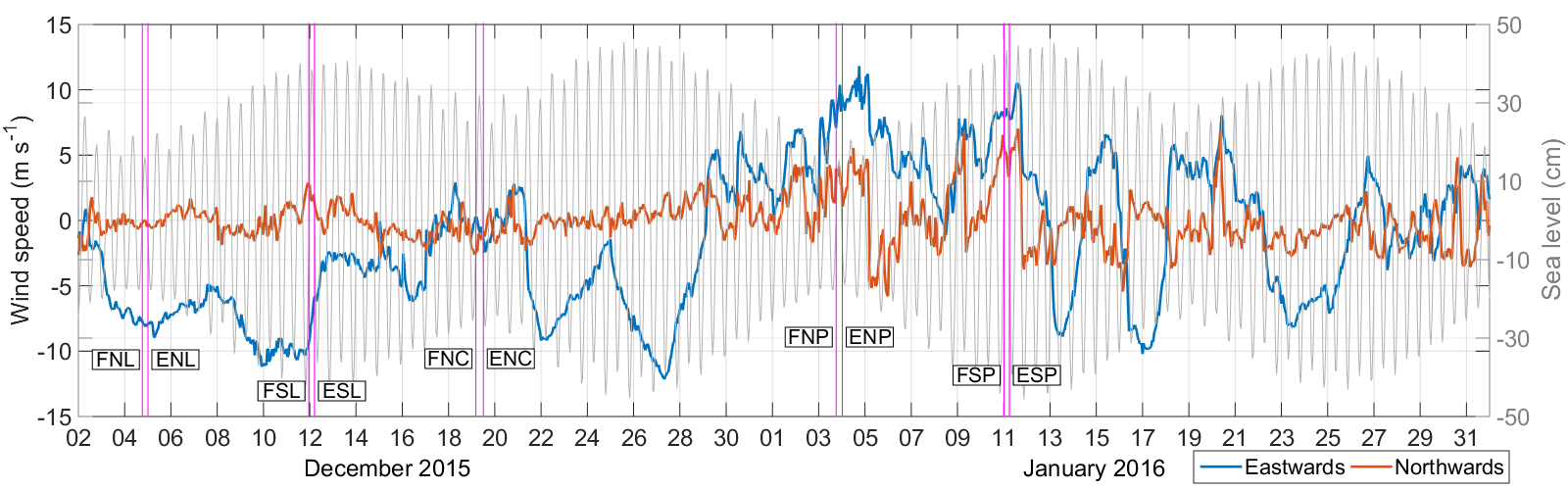
Time series of the two components of wind speed and sea level in Algeciras, observed during the hindcast. The magenta lines indicate the release time of the experiments, labeled according to the following three letters code: tide phase (Flood/Ebb), tide strength (Spring/Neap) and wind (Poniente (westerlies), Levante (easterlies), Calm).
In each experiment 2400 particles are released, randomly distributed within the area of each dock, and their trajectories are tracked during ten days. In a Lagrangian approach, as the one employed in this project, the curve of particles abundancy inside the UGAP provides a suitable proxy of the renewal capacity of the dock, and can be approximated by the equation C(t)=100exp(-t/a), which describes the variation of a tracer mass C through the time t as an exponential whose term a indicates the time needed by the initial concentration to be reduced of a fator of e (e-folding), and can be generally defined as flushing time. The following figure shows the flushing times computed in the 8 docks (UGAPs) analyzed under the 10 external conditions aforementioned.
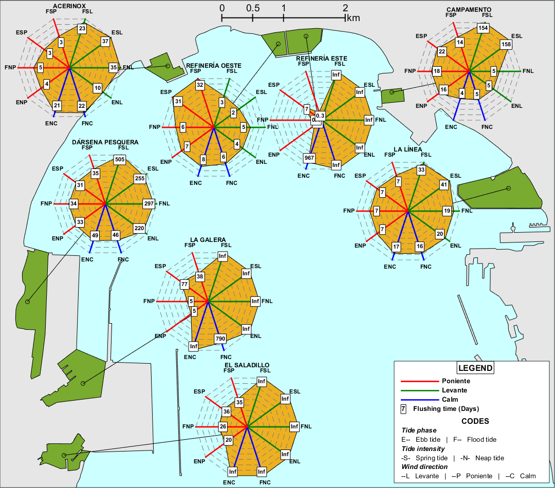
Radar charts of the flushing times ontained by the 80 experiments carried out in the Port of Algeciras. Wind and tide labeling is explained in the legend. The value Inf indicates e-folding times greater than 1000 days.
The most outstanding result is the noticeable bias of the wind in most of UGAPs, especially the ones located in the western side of the Bay. Almost all of them present flushing times one order of magnitude shorter under Westerlies than under Easterlies, and some of them as La Galera, El Saladillo or Refinería Este even show flushing times greater than 1000 days (labeled as Inf in the figure). Results obtained so far can be browsed in the interactive web page specifically designed to this aim, available at the address: http://oceano.uma.es/ugaps.php.
The following animation shows the result of applying the method described so far to the whole bay of Algeciras.
Animation of the trajectories of particles released in the Bay of Algeciras.
EXTRA CONTENTS
In the framework of the MOCBASE project, a test for the topo-bathymetric survey of the surf zone, has been carried out, by using a drone in the Bay of Algeciras. In the following link you can download the technical report of the test: Informe_Levantamiento_Dron.pdf
For further details, refer to the project reports availables down here: